A neighbourhood often suggests its own point of entry. You might plan an esoteric approach, arriving on foot to examine how surrounding districts connect, but usually the simplest method suffices: begin at the neighbourhood’s named station and let it be the gateway.
In the case of Shirokane, I have almost never arrived that way. For one reason or another, I have tended to enter from the north, crossing on foot from Minami-Azabu. It is some distance from either of the area’s stations, but in my personal geography of Tokyo, that boundary marks the start.
Accidental albeit, there is a historical logic to this. Shirokane takes its name from a wealthy landholder of the Ōei period (1394–1428), whose fortune in silver gave rise to the area’s name: shiro (白), meaning white, and kane (金), meaning metal, understood as silver. Affluence, in one form or another, has been close to its identity since.
Yet no rail line passed through Shirokane until 2000, when the Tokyo Metro Namboku Line and Toei Mita Line opened stations at Shirokane-Takanawa and Shirokanedai. Until then, the neighbourhood remained set apart, and I suspect that this may have suited it. It was not somewhere one simply dropped into. The area has been described as a “landlocked island”—distant despite being in company, never quite connected.
In a sense, that is why I am fond of Shirokane. That enclosed character, owing to the past absence of access, still persists. So, let's arrive on foot and see where the streets will, or will not, lower their walls.
The Last Shitamachi
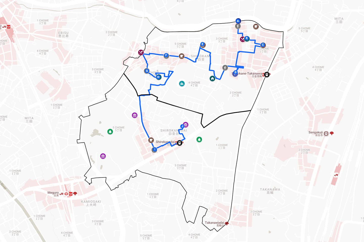
Follow along on the map.
Shino Bridge, or Shinohashi, marks the northernmost entry point to Shirokane, spanning the narrow, meandering Furukawa River. Here, Route 2 of the Shuto Expressway cuts overhead. It is a familiar Minato-ku scene: water, road, and elevated infrastructure compressed into a single convergence. Minato may be the city ward most segmented by expressway routes and thoroughfares, often producing pressure points of this kind.
Crossing the bridge, the river babbles through its concrete channel below, while above the expressway carries a constant, indifferent rumble of traffic. Suspended between the two, I feel, as a pedestrian, that I occupy a thin middle layer, made of the same dirt as the riverbed, yet more accustomed to the concrete.
On the far side of the bridge, that tension dissolves. The expressway, so dominant a moment earlier, becomes a kind of shelter, guarding a modest intersection where a cluster of shops and restaurants gather in an almost village-like arrangement. Its name appears on a nearby clock monument: Tokeidai Hiroba—Clock Tower Square.
Opposite, an archway marks the entrance to the local shopping street. The Japanese plainly reads Shirokane Shōtengai while the Roman lettering below gives “Sinohasi.” It follows Nihon-shiki, a system of romanisation in which shi appears without its now-familiar h. Restore the h and you get Shinohashi. Its use reflects an adherence to older or state-sanctioned romanization systems, a reminder that conventions shift.
The shōtengai extends into the neighbourhood, and I follow it. Contrary to expectation, there are no boutiques or wine bars—no evident attempt to retrofit the street into something more contemporary. Instead, there are signs of daily use: a cleaning shop, a tobacconist, a small electronics store. Some shutters remain down; others open intermittently. This may reflect the area’s long isolation, when even through the economic growth of the mid-1950s to early 1970s there was little reason for passing traffic and less pressure to change.
At the local supermarket, a narrow side passage draws me away from the shopping street. It bends through a pocket of tightly packed homes, interspersed with a few local eateries and occasional workshops. In the Meiji period, small factories clustered in this low-lying stretch near the river, taking advantage of available land and water transport along the Furukawa. The town that formed around them is now sometimes thought of as “Minato’s last shitamachi”, or “downtown”. The atmosphere feels open and human, albeit in a subdued way.
Takanawa to Hikawa
A short detour east draws us out of the shōtengai and back towards the Shirokane-Takanawa Station side. Shirokane Tower rises above the surrounding streets, its verticality signalling larger plots, newer development, and a different order of wealth. In small pocket parks in its shadow, children play under a watchful calm. I sit for a while in the ambient hum—a space where one is surrounded, but not required; present, but not involved. It is a form of solitude in which I feel at ease.
I return to the shōtengai and follow it to its natural conclusion. Where the shopfronts end, the grounds of Shirokane Hikawa Shrine lie across the narrow but busy Tokyo Prefectural Route 305. The shrine’s approach is set back between mid-rise blocks, as though frozen in place as the neighbourhood arranged itself around it.
At the entrance stands a large torii gate, its metal surface weathered to a deep brown. Steps lift upward, and once within the precinct, the surrounding density recedes slightly. Hikawa Shrine is said to date to the Hakuhō period (c. 645–710). Like much in Tokyo, what stands today reflects repeated interruption: destruction in the Great Fire of Meiwa in 1772, damage again during the air raids of 1945, and a post-war reconstruction completed in 1958.
On the way back down to street level, the view opens outward and downward onto the layered roads, buildings, and power lines. It is a familiar yet pleasing juxtaposition: the traditional gate set against the modernity of urban development below.
Little Red Kissa
Leaving the shrine, I turn off Route 305 onto Sankōzaka. Zaka, a modified form of saka (坂), denotes a slope. The incline here is modest, just enough to raise the heart rate. The route bends and narrows into a tightly woven residential enclave. Front doors are reached by short flights of steps, bicycles tucked into narrow gaps, with small gardens or potted plants softening the edges.
It shows how the neighbourhood accommodates its topography—a lesson through which the city teaches me, each time, to loosen my grip and become more adaptable to life’s ebb and flow.
Looping around, the descent returns me to Route 305, which I cross into the north side’s residential streets. A scattering of shops and vending machines appears; at the far end, a flash of colour interrupts the otherwise muted palette. Coffee Shop Candy announces itself with a curved awning in a vivid, almost lacquered red, set against straightforward, stubborn white typography. A pair of yellow wooden benches, set within well-maintained greenery, completes the scene and prompts me to stop into this kissaten.
Inside, the afternoon light meets dark wood interiors and small tables arranged with practicality. Stained glass at the door and windows casts muted colour into the room, while potted plants gather in corners and along sills. The couple running the café carry an easy manner; I am seated and asked for my order.
Around me, small groups of salaried workers filter in, sleeves rolled and ties loosened, speaking in animated tones. It feels like a lunch spot chosen as a release valve from the workday. For me, it offers a place to recalibrate over coffee and hayashi rice before setting off again.
Architecture Row
Exiting the kissa, I head south towards Tokyo Metropolitan Route 703. As the artery passes through Shirokane, it narrows slightly, and presents a sequence of varied buildings. I have come to think of this stretch as “architecture row”, where the neighbourhood’s density and history produce a distinctly non-uniform edge.
A narrow, two-storey house appears first, its upper level clad in pressed metal panels stamped with a repeating diamond pattern, set lightly above a brick-faced ground floor kissaten. Nearby, a mid-rise apartment block follows a different logic: poured concrete, symmetrical balconies stacked along a central spine, its geometry clean and unapologetically late modern.
Between them, older shopfronts persist. One remains shuttered, its corrugated metal door oxidised to a mottled green. A few wooden structures, too, survive: darkened timber frames, sliding glass panels, and tiled rooflines that point to pre-war construction, weathered but intact.
Taken together, these buildings resist being tied to a single period or style. They sit in adjacency—close together, yet somehow separate. In the compressed space of Route 703, I find myself relating to them, recognising in their separation something of my own.
Circling the Heart
From Route 703, the street loosens again. We wind through a series of back lanes, crossing Nazare-dōri almost without noticing, before beginning a steady climb up Meijizaka. Shirokane is partly defined by its slopes—named inclines that mark shifts in elevation, some slight, others more pronounced. Each has a small wooden post, easy to miss if you are not looking. They lend the movements of ascent and descent credibility, as though they have been formally acknowledged, rather than treated as something to be corrected through infrastructure.
Meijizaka leads us to a more withdrawn residential plateau. At the top, we enter streets that bend with houses set back behind walls or hedges, and an atmosphere that recedes into privacy. The path carries us onward to the next slope, Shōkōzaka, which follows the western perimeter of the Sacred Heart School grounds.
A continuous boundary runs alongside Sacred Heart—red brick walls, dense planting, and glimpses of larger buildings set deep within the site. In the Edo period, the land formed part of a daimyō estate; later, it passed into institutional use, and today it houses one of Tokyo’s most prestigious international schools. As the alma mater of Empress Michiko, it reinforces Shirokane’s association with education, refinement, and social standing.
The extensive plot sits at the neighbourhood's geographical and, perhaps, symbolic centre—its heart in every sense. Yet the centre cannot be traversed. The grounds remain closed; outsiders can only walk the perimeter, aware that this heart is off limits.
Platinum Elevation
From Shōkōzaka, I continue southwest through one final residential stretch, where the serpentine streets carry us across an invisible boundary into Shirokanedai. Dai (台) denotes elevated ground, and the transition leads me to a broad avenue where the atmosphere shifts to something more outward-facing. I've arrived at Platinum-dōri.
Where shirokane refers historically to silver, “platinum” was a later embellishment. Along this stretch of Gaien Nishi-dori, the idea of Shirokane as a lifestyle took hold in the late 1990s: cafés, boutiques, and tree-lined pavements forming a stage for a new kind of visibility. From this moment, the term Shiroganeze emerged—a media-coined shorthand for a particular form of affluent, aspirational femininity, less a demographic reality than a projection circulated through magazines and television.
Walking the street now, that layer remains, but lightly so. Ginkgo trees, manicured storefronts, and the broad plots of European- and North American-inflected buildings contribute to a composed, self-aware streetscape. It could be read as a quieter alternative to Omotesandō.
Near the bottom of the road, I duck into Seiji Asakura Coffee Stand, a small offshoot of the more well-known Boulangerie Seiji Asakura, where many of the same baked goods are available without the queue. I choose an appropriately luxuriant white chocolate fig bread and take a seat on the bench outside, watching the avenue fade into dusk.
Preserving Distance
Platinum-dōri runs straight until it ends at a T-junction near Shirokanedai Station. The train network finally appears, marking the point at which a once relatively secluded district became fully connected to the city around it. Here, I will leave you; from this point, there are several ways to continue.
You could turn towards the Tokyo Metropolitan Teien Art Museum, where a former princely residence and its surrounding gardens provide a formal conclusion. Alternatively, nearby, the Minato City Local History Museum presents a more welcoming early Shōwa-era public building whose preserved structure holds together layers of the ward’s past across several floors.
Otherwise, the Institute for Nature Study opens into a preserved fragment of Musashino landscape—dense with woodland, marsh, and pond. Another former daimyō estate and later an imperial property, it was left largely undisturbed. Terrain and ecology of this kind, carefully conserved, are rare in central Tokyo.
But just as easily, you might do something that until relatively recently was not possible at all: descend into Shirokanedai Station, step onto the Namboku or Mita Line, and leave without a trace. For all we have seen, the neighbourhood, distant as it keeps itself, does not seem to mind. Nor does it deny the possibility of another encounter.
And so it remains: a landlocked island, briefly connected and just as easily departed.
Until we meet beneath Route 2,
AJ
Whether today’s newsletter has informed your travels, deepened your knowledge, or offered a moment of calm after the week’s demands, consider becoming a member.
Members receive:
✓ Archive access
✓ Neighbourhood Collection
✓ Bookshop discount
✓ Periodic long reads
✓ Writers' field notes
Memberships costs no more than a monthly coffee at the kissaten and help keep the newsletter free each week while supporting the production of in-depth guidebooks, and long-form travel writing.